

Split a list of addresses into turfs, each with a walk list
Group addresses into patches of a set size, give every address a patch and a place in the knock order, and print a sheet to hand out.
Best for
Anyone who sends people door to door: campaign and petition organisers, charity fundraisers, survey teams, meter readers, leaflet rounds. You do not need any mapping experience. You end up with every address given a patch and a place in the knock order, a count of doors in each patch, a sheet of all the patches to print, and a walk list for each person.
A patch of doors for one person is called a turf in canvassing. The same method makes rounds, beats and patches.
The example in this guide is a petition drive in Lamond-Riggs, a neighbourhood in Washington, DC. The file is every active residential address in one neighbourhood district (single member district 4B10) from the District of Columbia's Master Address Repository, as the city publishes it: 785 addresses, 806 homes once flats are counted. Results vary from run to run, so treat the figures here as one example.
What you need
- Your addresses, as a spreadsheet with latitude and longitude or an address on each row. A count of homes at each address helps where there are flats.
- The size of a turf, as a range of doors.
- A Free, Creator or Creator Max seat.
Before you start
- Say what a door is. A block of flats is one address and many doors. If your file has a count of homes at each address, say to count those.
- Say what makes a good patch. "Neighbouring streets a person can walk" and "both sides of a street together" are the two that matter most.
- This starts from points. To build territories out of whole areas, such as counties or postcode districts, see Split accounts into balanced sales territories.
The prompt
I'm coordinating volunteers for a door-to-door petition drive in our neighbourhood, Lamond-Riggs in Washington, DC. Attached is every active residential address in the district: 785 addresses. Split the addresses into turfs of roughly 50 to 150 doors each, each turf one compact patch of neighbouring streets that a person can walk, keeping both sides of a street together where you can. Then give me a map of all the turfs, numbered and in different colours, that I can print and hand out, and a walk list for each turf with the addresses in the order to knock them. Tell me how many turfs there are and how many doors are in each.
What to expect
Mapstack groups the addresses into turfs
It places every address and groups them by closeness into patches inside your range. In the example the 785 addresses became 8 turfs of 97 to 105 doors each, all inside the 50 to 150 asked for. Flats were counted by the homes in them, so the doors add up to 806, not 785.
You get a table of the turfs: the addresses and doors in each, and the streets it covers. Check that the doors add up to your total.
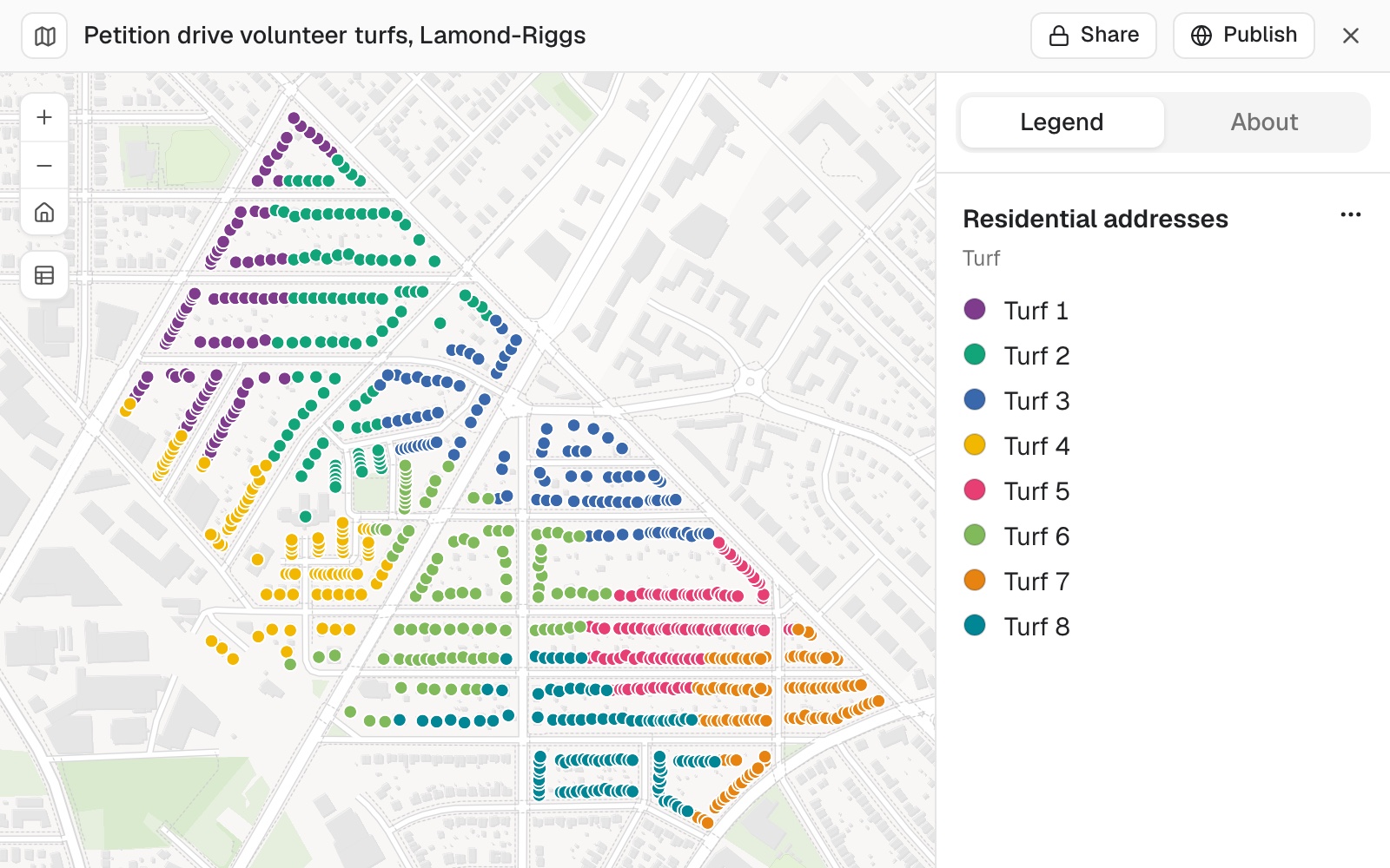 Example: the 785 addresses of Lamond-Riggs, each coloured by its turf. There are 8 turfs of 97 to 105 doors.
Every address gets a turf and a place in the order
The result is one dataset: your addresses, each with its turf number and its place in that turf's knock order. The order runs street by street by name, and then by house number, with both sides of a street in the one list.
A walk list is that dataset filtered to one turf. Open it, filter by turf, and select Download, then CSV. Or ask for one turf's list in the chat.
You get a sheet of all the turfs to print
The print is a Letter or A4 sheet with every address as a dot in its turf's colour, a label at the start of each turf, the street names underneath, a key, a scale bar and a north arrow. Download it as a PDF or a PNG.
The turfs are shown as coloured addresses, not as outlines. An outline would have to be invented, and the addresses are what a volunteer needs.
You ask for one turf on its own
Make a printable sheet for Turf 3 on its own, so I can check it before you do them all.
You get a sheet at a larger scale with only that turf's addresses, and its walk list as a table in the reply: 99 addresses in the example, from first door to last.
Where a page cannot hold both a readable map and a long list, Mapstack says so and asks how you want it: the map on one page and the list on another, or a smaller turf. Then ask for the rest:
That works. Make the sheets and lists for the other seven turfs.
The same method draws districts
Where the patches have to hold equal numbers of people, not doors, the building blocks are census areas and Mapstack fetches them. A county elections office in Solano County, California, asked for five supervisor districts, each within 5% of an equal share, in one piece, with cities kept whole where the numbers allow.
Mapstack fetched 2020 Census population for the county's 6,910 census blocks and worked out the equal share: 453,399 people, so 90,680 a district. It named the three cities too large for one district and kept the four smaller ones whole. Every district in its first plan came within 1.5% of the equal share. The current district lines, attached as a file, were drawn dashed over the new ones.
Then say what you would change, in plain words:
District 4 reaches Dixon by a thin strip. Give it a broader connection and keep every district within 5%.
Mapstack redraws the plan and gives you the new table.
Make it your own
We only have six volunteers on Saturday. Make it six turfs and tell me how many doors each one has now.
How far is each of our current districts from an equal share, on the same census figures?
Common questions
Can I set the number of turfs and not the size?
Yes. Say how many people you have, and the addresses are shared out between that many patches.
Does the knock order follow the best walking route?
No. The order runs street by street by name, and then by house number. For a route worked out on the road network, with a time at each stop, see Build territories and plan routes.
Can it draw districts that have to be equal in population?
Yes. Name the areas to build from, the number of districts and how far each may sit from an equal share. Mapstack fetches census population for the areas, keeps each district in one piece, and gives a table of each district's population and its distance from the ideal. You can attach the current lines and have them drawn over the new ones.
Should the walk lists go on a public page?
A walk list holds the addresses of private homes. Share the lists with your volunteers, and keep a public map to the patches.