

Split accounts into balanced sales territories, then test a change
Count your accounts into areas, group the areas into one territory per rep with a fair share each, and see what moving an area would do to the numbers.
Best for
Sales and field operations managers who need to split accounts fairly between reps, when a rep joins or leaves or at the yearly review. You do not need any mapping experience. You end up with a territory map, a table showing how far each territory is from an even share, and a list of every account with its territory, ready to load into your CRM. You can then ask what a proposed change would do before you make it.
The example in this guide sells to veterinary clinics in Texas. A real team would bring its account list from the CRM. Here the accounts are found rather than brought: 4,132 veterinary clinics and animal hospitals from Overture Maps open places data, counted into the 254 Texas counties from the US Census Bureau. The six reps are based in Dallas, Fort Worth, Houston, Austin, San Antonio and Lubbock. With your own accounts, attach the CRM export and keep the shape of the asks. Results vary from run to run, so treat the figures here as one example.
What you need
- Your accounts, as a spreadsheet with an address or latitude and longitude on each row, or the kind of business to search for if you are prospecting a market.
- The building blocks for territories: counties, ZIP codes, postcode districts or similar. Name them in the ask and Mapstack fetches them, or attach your own.
- Where each rep is based, if territories should form around them.
- A Free, Creator or Creator Max seat.
Before you start
- Territories are made of whole areas. An area is never split between two reps, so the totals are as even as the areas allow. Smaller areas give a more even result.
- Balance on something that adds up: accounts, sales, visits. A rate or an average cannot be shared out.
- Say "joined along a border" if corners will not do. "In one piece" on its own lets two areas that meet only at a single point count as neighbours, and a territory held together at a corner is one piece on paper but not on the road. Texas has 64 pairs of counties that meet only at a corner.
The prompt
We sell to vet clinics. Find every veterinary clinic in Texas, count them by county, and split the state into 6 territories built from whole counties, each in one piece with its counties joined along a shared border, balanced on clinic count. Our reps are based in Dallas, Fort Worth, Houston, Austin, San Antonio and Lubbock.
What to expect
Mapstack gathers the accounts and the areas
With no file attached, it searches open places data for veterinary clinics and animal hospitals in Texas, which keeps grooming, boarding, pet sitting and pet shops out, and leaves out places marked as closed. In the example that came to 4,132 clinics once listings of the same clinic were merged. It fetches the 254 Texas counties and counts the clinics into each one: Harris County, round Houston, holds the most with 515, and 46 counties hold none. Each of these is a dataset in your session that you can open and check.
Places data is a listing, not a register: it can miss a clinic, keep one that has closed, or let a near-miss through. Open the clinics dataset and look at the categories before you rely on the count. With your own account list, the count is only as good as the addresses in it.
It groups the counties into territories
The counties are grouped into six territories, each formed around one rep's home county and balanced on the clinic count, with every county joined to the rest of its territory along a shared border. The even share is 688.67 clinics, and every territory came within 2% of it: Austin 702 in 15 counties, Lubbock 693, Dallas 689, Fort Worth 686, Houston 682 in 8 counties, and San Antonio 680.
Where accounts are thin, a territory has to cover more ground to reach its share. Lubbock took 91 counties, the whole of West Texas from El Paso to the Panhandle, and still needed Collin and Denton, the 382 clinics in the northern Dallas suburbs, to reach 693. That is the cost of balancing on one measure; if drive time matters too, ask for territories kept tight by drive time.
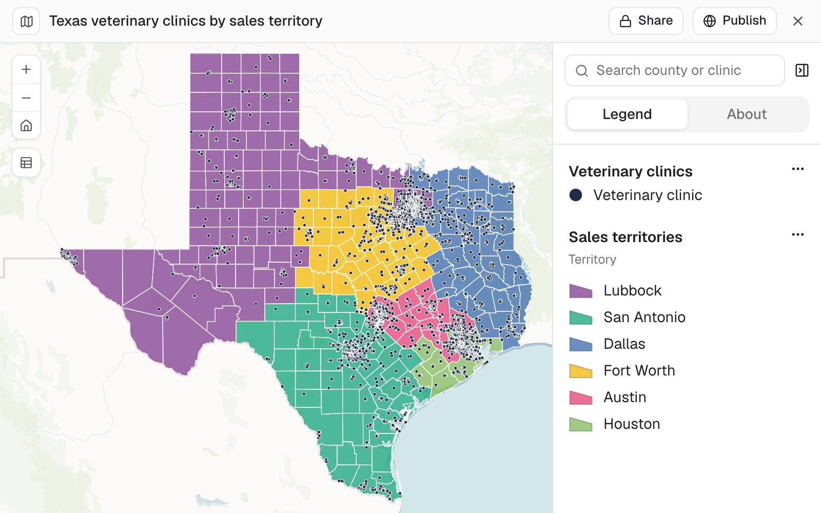 Example: the six territories, each a block of whole counties joined along their borders, with the 4,132 clinics on top. Lubbock (purple) runs from El Paso to the Dallas suburbs.
You get the table and the list for the CRM
Ask for both at once:
Give me a table of each territory's clinics and how far it is from an even share, and the list of clinics with their territory so I can load it into the CRM.
The table gives each territory's clinics, the even share (688.67) and the difference in clinics and in percent: from Austin, 13.33 over (1.94%), to San Antonio, 8.67 under (1.26%). The list is a new dataset: every clinic with its name, address, county, county code and territory. Open it and select Download, then CSV.
You test a change before you make it
Ask what a move would do, in the words you would use with the team:
What happens to the numbers if we give Denton County to the Dallas rep?
Denton holds 165 clinics. Moving it would take Dallas from 689 to 854 (+23.9%) and Lubbock from 693 to 528 (−23.8%), with the other four unchanged. A move that size unbalances both territories, so Mapstack offers to test smaller moves instead.
The what-if is an answer in the chat. To make a change for real, ask for it and Mapstack redraws the territories and the list.
You look at the map the way a rep would
Ask for one, and say what the team needs to see:
Make a map of the six territories with the clinics on top, each territory its own colour, and each territory's clinic count and rep base in its pop-up.
Check that every territory reads as one block of counties sharing borders, and look at the long ones: they are where a rep will spend the most time driving.
Make it your own
Keep every territory within a four-hour drive of its rep's city, as close to an even share as that allows, and show me the new table next to this one.
Common questions
Can every territory be joined along a border, not just at a corner?
Yes. Say so in the ask: "each in one piece with its counties joined along a shared border". Left unsaid, two areas that meet at a single point count as neighbours.
Can the territories be more even?
Yes, with smaller areas. Territories are made of whole areas, so the totals are only as even as the areas allow: ask for ZIP codes instead of counties.
One territory is enormous. Can it be kept tighter?
Yes. Accounts are thin there, so it needs more ground to reach an even share. Ask for territories kept tight by drive time as well as balanced on accounts, accept a smaller share for that rep, or base a rep nearer the accounts.
What happens to accounts outside every area?
They belong to no territory. Ask "Are any clinics not in any territory?", then give each one to the nearest territory or remove it. They are usually just over a state or country line, or have a wrong location.
How do I check the table?
Check that the territories add up to the total (4,132 in the example) and that each difference matches its count and the even share (688.67). If a figure does not add up, ask where it came from and for the table again from the account list.