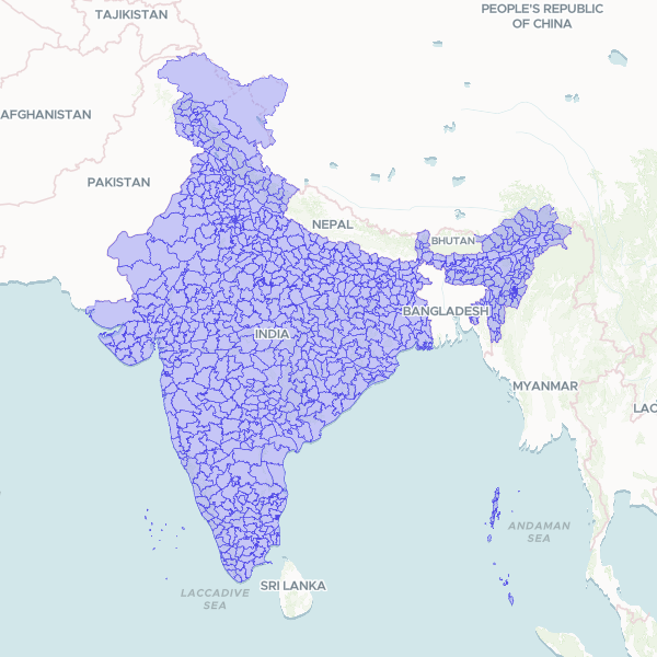
The 733 districts (ADM2) of India, covering all 36 states and union territories. Published by the Geological Survey of India on the National Water Data Portal; the layer names Survey of India as its boundary source agency. Join on `district` (a name, populated on all 733 rows) or `dtcode` (the LGD district code, 731 unique). `state_name` and `stcode` are carried so you can disambiguate the five district names that repeat across states — Bilaspur, for example, exists in both Himachal Pradesh and Chhattisgarh. BEFORE YOU JOIN BY NAME: this publisher's spellings often differ from the forms used in other Indian datasets, in four distinct ways. Transliteration (Jajapur / Jajpur, Kendujhar / Keonjhar, Anugul / Angul, Jagatsinghapur / Jagatsinghpur, Saraikela / Seraikela). Direction words placed last and in English ("Medinipur East" for Purba Medinipur, "24 Paraganas North" for North 24 Parganas, "Dinajpur Uttar" for Uttar Dinajpur). One publisher typo, "East Singhbum", missing an h, sitting beside a correctly spelled "West Singhbhum". And at least one pre-rename form, "Baloda Bazar" for Baloda Bazar-Bhatapara. Mapstack's join tolerates most of these, but a key whose direction word is in a different language from the publisher's (Purba vs East) will not match. Joining on dtcode avoids all of it. COVERAGE AND VINTAGE: 733 districts against the Local Government Directory's 784 live entries. This is a current division rather than a historical one — the 2011 Census had 640 — but it predates the most recent district creations, notably in Chhattisgarh (28 here) and Rajasthan. TERRITORIAL DEPICTION: an official Government of India product, carrying India's full official territorial claim, including Aksai Chin and Pakistan-administered Kashmir. The districts of Mirpur and Muzaffarabad are present; the publisher gave both the placeholder code 999, which has been cleared to null so the code column never carries a fake identifier. Both remain named and joinable by name. Other publishers depict these areas differently.
Source: "District Boundary", Geological Survey of India, on the National Water Data Portal (National Water Informatics Centre, Ministry of Jal Shakti). Shapefile dated 2025-01-13, portal record May 2025. Retrieved 2026-10-08; district_nwic_shp.zip, 38,609,393 bytes, sha256 0c8253fed246a2823c6b08cef25bb40a1cd388334a425f18826f0d598879c526. Native CRS EPSG:7755 (WGS 84 / India NSF LCC), reprojected to EPSG:4326. Attributes kept: district, dtcode, state_name, stcode, state. Dropped: objectid and id (internal row furniture) and shape_leng / shape_area (publisher-derived measures, which go stale once geometry is generalised). The publisher coded the two Pakistan-administered Kashmir districts with the placeholder 999, a value outside the real code range of 1-784 and the only duplicate code in the layer. It was normalised to null, which leaves dtcode unique across all 731 coded rows. Generalised with ST_SimplifyPreserveTopology at 0.0003 degrees, 3,125,505 vertices down to 827,546. Sized against the smallest unit rather than the typical one: Mahe, at 10.3 km2, retains 73 vertices. No feature was emptied. 733 source features in, 733 published; none dropped, filtered or dissolved. Inspected across all five standard views before publication: complete national tiling with no coverage holes, Andaman and Nicobar and Lakshadweep present, clean shared edges between neighbours, the Sundarbans delta resolved, and archipelagos rendering as separate islands rather than one sea-merged mass, which confirms the shoreline-clipped land variant rather than a water-inclusive one. Conversion produced no GeometryCollections. The production pipeline applied a validity fix to 6 of 733 geometries and normalised mixed Polygon/MultiPolygon. Verified by joining two real user tables through the production join path: 26 of 27 districts matched on name in both. The single failure was "Purba Medinipur" against the publisher's "Medinipur East" — a naming difference, not a missing unit.
Showing 10 of 733 rows — open the Table tab for the full, sortable dataset.
We use cookies to improve your experience. Read our privacy policy.